Tuesday, November 11, 2014

Picacho Peak

Veteran's Day Hike!
November 11, 2014
Picacho Peak

Happy Veteran's Day! We are thankful for all who have served and are currently serving. Tonight we talked a bit about how different next year's Veteran's day will be, after Curtis has begun his service. For today, we were thankful for a day off from school so that we could fit in another hike.

One year ago today, we went to Picacho Peak State Park for the first time. Our main goal was letterboxing, and we planned to go as far as we could. We were able to get 5 out of 6 letterboxes, and at the fifth one we decided to have lunch and call it a day. Altogether, we hiked about 2 miles. How cute. ;)

Picacho Peak, while heading North on I-10. 11/11/13


A while later, Curtis was looking up the trail, and he learned that to get to the peak, it required using cables to get up some rather steep parts. I heard that and instantly thought, nope, I'm good. I'm fine with never ever doing that. Silly me... I think that a lot, actually. Curtis or his friends will tell me about a hike, and if it's much more challenging than anything I've done, I'll usually forget about it and think that I'll be completely content with my life if I never, ever do it. That's how I felt about hiking Mt. Humphreys, and we all know how great that turned out! So of course, somehow I was convinced to go today, and I did not regret it... I never regret these adventures. :)

Curtis looking for a letterbox. 2013
 There's a lot of history around this area. The Skirmish at Picacho Pass occurred here during the Civil War. There's a memorial set up that we enjoyed looking at last year, and since then Curtis has done a lot of research. If you want to know more about it, Curtis has written a great summary of the Civil War in AZ here.

Desert scenery around Sunset Trail. 2013

The view of Picacho Peak from where we stopped last year. 2013

The desert of Pinal County. 2013

Us last year - hiked 2 miles. 2013

 Today, we enjoyed sleeping in, playing with our puppy, and running some errands before finally heading out to Picacho Peak. It's 45 minutes North of Tucson right off the I-10 - if you've ever driven between Phoenix and Tucson, you've probably seen it - it's one of the most unique peaks around here. We began our hike at 10:30, though we really would have benefitted from starting earlier. It's all desert out there, and the sun just beats down on you. 

We took the Sunset Trail, which is 6.2 miles roundtrip. It starts on the far North side of the park, makes its way up, down, and around many gullies before it finally decides to start ascending to the peak. At that point, the trail completely consists of loose rocks that slide everywhere, and the trail is steep, narrow, and difficult to find sometimes. In the last mile, it gets so steep that they put in cables to help you make it up the difficult rock face. I don't have any pictures of the entire way up because we were so focused on making it [alive]. But after two hours... we made it!

Us today - at the peak! Hiked 6 miles!
 As always, the views and the feeling accomplishment make a great reward for all the hard work. We spent a bit of time relaxing, eating, geocaching, and picture taking.

On Picacho Peak - facing Northeast

Facing North
Panorama of Picacho Pass

Facing South - the Catalina Mountains are in the distance.

All of I-10 seen from the peak
 After this, we began our hike down. We finally pulled out my phone to capture the memories of our first experience cable-hiking. As it turns out, it was actually more difficult going down than going up!

On our way down - these are the cables we had to walk up/down!
It's harder going down than going up.
And the trail goes where??

With every set of cables, we had to decide if it were better to go down facing forward or backward. I tried both ways, and prefer facing forward if it's an option. They designed it so that there would be places to put your feet the whole way up or down, but when going down it's almost impossible to see the crevices where your feet should go. Pair that with having to look down at how high you are, and it's a nightmare for someone scared of heights! When I was going up, I went as fast as I could without looking down so that I could get it over with, and the adrenaline carried me up. Not so with going down!

Straight down!
Gloves - completely necessary.
 We had stopped to buy cheap gloves before hiking, and it really paid off. Even though they didn't offer traction on the slick cable, they really did protect our hands, so we highly recommend bringing some if doing hiking like this!

Ahhhh!

Curtis demonstrating going down backwards.

I look like a midget! Going down our last set of cables!
 I was also really thankful to have Curtis behind me when we were going up, and in front when we were headed down, so that if I fell he could catch me. ;) It really helped having him in front when I was going down though, he helped me find my footing when I started to panic. Over all, I'm very thankful that we had this experience so that we're ready for it in the future!

Yes, these go straight up...

Now we can proudly say we stood on that peak!

Sunday, November 9, 2014

2 Peaks, 1 Hike

November 8, 2014
Carr and Miller peaks

Arizona's 20-20 challenge - 20 diverse and prominent peaks and canyons throughout the state of Arizona. We have hiked the #1 peak - Mt. Humphreys - and the #11 - Mt. Wrightson. We've also been to the peaks of Heliograph (#6) and Mt. Lemmon (#17), but those are both easily done by driving up the highways that take you up a significant amount. We know we won't be able to complete all the peaks and canyons in what time we have left here, but we like to take any opportunity to check some off the list. Miller (#10) and Carr (#16) are both found in the Huachuca Mountains, South of Sierra Vista, about 1.5 hours Southeast of Tucson. Curtis found an easy way for us to hike them both in one trip, as only a 4 mile long ridge lies between the two.

Facing toward Sierra Vista. If you enlarge, you can see the Aerostat, which is just a speck high in the sky.

We had two options for doing the hike: we could drive to one trailhead, hike to both peaks, then hike back to the car. The other, more complicated option was bringing 2 vehicles, parking one at a trailhead for one peak and then driving to the other peak's trailhead, hike both peaks to the other car, then drive back. We ended up doing things the easy way with one vehicle, mostly because the trailhead for Miller peak is rather close to the Mexican border. In the end, we were glad we did it that way - it didn't add on too much of our hike, and saved a lot of driving time and logistics.

Facing East

We decided to begin at the trailhead for Carr Peak. In our group was Mitchell, our friend Anna who lives in the Phoenix area (though we've known her for many years back in Iowa!), Curtis, Charlotte and I. We arose early and took off at 5:30. After seeing a glorious sunrise and passing through Sierra Vista, we took Carr Peak road up the mountain for 5 miles to the trailhead. This may have been the hardest part of the whole trip - the road is very rough and rocky, and one way for a good portion. Thankfully, we didn't come across any other cars (it was too early for that!) and made it safely to the trail parking lot around 7:15. As hard as the road was on Mitchell's Jeep, we were all very grateful that we wouldn't have to walk up this distance - driving up took over 2000 feet of elevation off our trail! It was chilly and windy for a while, but felt great while we were walking. 

Facing West, at the ridge that we would soon be hiking to get to Miller Peak.

The first 2.4 miles were gradually ascending the rest of the way up the mountain. The trail was very easy by our standards - hardly any boulders to climb over and very well maintained. The trail started in a forest with aspen and fall colors all around, then opened into walking along a ridge around the peak. The sky was perfectly clear and the visibility was great for the whole day. It made us all encouraged and it was so easy to enjoy - even for Charlie!

At Carr Peak, facing North toward Sierra Vista.

After the first 2.4 miles, we came to the intersection with the short trail leading up to Carr Peak. It was a bit steeper than before, but we believe that anyone could probably make it - it was only a mere .3 miles up to the top, and the reward was so great for such minimal effort!

Facing West, toward the other mountains in the Huachuca Mountain range.

At this point, it was quite windy at the top, which was at 9250 feet above sea level. It was only around 8:45 by the time we reached the peak. We had a 360 view from the peak, and we were the only ones there, making our time at the top very enjoyable!

Facing South, looking at Miller Peak - we're coming for you!

Panorama of the East, with Miller peak on the far right.

Peak picture #1 for today!

After spending a little time at Carr Peak, we continued on - we still had a long ways to go to reach Miller and hike back! However, this was really some of the easiest hiking we've done. The ridge had its ups and downs, but it wasn't ever strenuous until we reached the half mile trail to Miller peak. 

Ridge hiking is a breeze, and so much fun!

Even though it was so easy, the trail didn't seem like it was hiked very often. The brush was very overgrown, so make sure you're wearing long pants!

We walked on part of the Arizona Trail on the way to Miller.

Our trail joined with the Arizona trail maybe 1 ½ - 2 miles in. We've hiked bits and pieces of it while letterboxing, but this was probably the most secluded and quiet part that we've been on. Up till this point, it was around 10 - 10:30 and we hadn't seen anyone out here yet.

Bathtub Springs

There is one very unique part of the far South part of the Arizona trail, and it's called Bathtub springs. Curtis heard about it several years ago, and he's always told me about how someone brought a bathtub out to the AZ trail to use as a water source. We just so happened to come across it today, and I think it was one of the highlights, right up there with reaching the peaks! 

At Miller Peak! Facing East - about ⅔ of this picture from the right is Mexico. Just above the saddle in the foreground, you can see a black line running diagonally upward from right to left - that's the border fence!


After the springs, the trail starts ascending little by little, until we came to the trail intersection with the half mile trail leading up to Miller Peak. The last half mile was steeper and we stopped a few times to catch our breath, but it didn't take long before we made it - ahead of schedule!

Facing East - our view while we enjoyed lunch

The moment when you reach a peak after working hard for it and anticipating it the whole way is such an exciting and breathtaking moment that is always worth looking forward to. Even on my hardest and worst hikes, that moment always cheers me up and gives me a little burst of energy. Today, we got to experience that "moment" twice, and both times were incredible.

Facing Southeast

Facing South

Facing North- Carr is off on the left, Sierra Vista is in the center.

Facing Southwest 
Charlie snuggling with her Uncle Mitch

When you're at the top of a peak, time seems to stop. After hiking for so long (around 6.5 miles at this point),  we're able to finally sit, relax, and take it all in. It doesn't matter what we brought to eat - everything tastes good! Somehow, we always spend about an hour at any peak. It's always worth it.

Facing Northwest - toward the other Huachuca Mountains

Facing Southwest into Mexico

This picture captures the whole area we just hiked through - from North of the mountain on the right, up to that peak, and across the whole ridge up to Miller.

Most of the time after doing a hike, I really feel no desire to go redo it another day. Once is usually enough - however, this is one hike that I would love to do over and over again! I know the weather we had and the peace of the trails may not ever be as perfect as they were this day, but the trail and views alone made it worth it!

Family peak picture #2

Who has no thumbs and has hiked 3 of the 20/20 AZ peaks? This kid!

Charlie was able to hike most of the way from the beginning to Miller peak, and she walked quite a bit on the way back, but Curtis and Mitch took turns carrying her so that she wouldn't wear herself out. We rewarded her with peanut butter and PB cookies along with her food. :)

The guys enjoying Bathtub Springs :)

After spending an hour at the top eating, enjoying, throwing rocks, and picture taking, we began heading back. It was about 12:30 at that point. We ran into one small group on the way down. They were only hiking to Miller peak, and they had started in Miller Canyon. This meant that they had to hike up the 2000+ feet that we had skipped by driving up - and it showed. We all agreed that we loved the way we did it, and didn't feel like we missed out by hiking up the whole way. The hike we did on its own was 12 miles - plenty for one day!

Charlie enjoying the springs!

Looking back at Miller peak and that park of the ridge.

We made it back to the Jeep at 3:30, still feeling great and gushing over this amazing new hike we had found. We highly recommend it to anyone looking for a moderate day hike in Southern Arizona! Hiking it in early November was a great experience, no promises that it'd always be so easy, but the views and experience is worth every step!


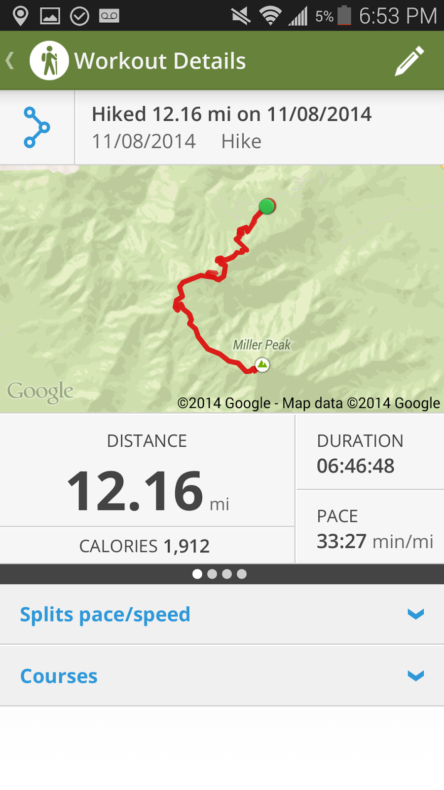
Workout details from the Map My Hike application. I only paused our time at the 2 peaks, so our total hiking time plus several short breaks ended up being less than 7 hours - not bad for 12 miles!


The elevation changes throughout the hike. This is why it was so easy! Once you make it to the intersection with the Carr Peak trail, it's all gradual changes, very easy and so worth it!

One last note - at Fort Huachuca in Sierra Vista, there is a tethered balloon surveillance system called the Aerostat. It was visible almost the entire hike, though in these pictures it turned out as a tiny speck. We joked about how it was watching us the entire time. It is visible in 4 of the pictures I posted - can you find them all? Click on the pictures to enlarge and look for them!

Thursday, November 6, 2014

Why My Puppy isn't a Basset Hound

Recently, I've noticed a few characteristics about my puppy Charlotte that make me rethink what kind of breed she is. I mean, she obviously has the looks - the wrinkles, the long ears, the build...but the way she acts falls short of being your typical hound dog.


-Basset hounds have the 2nd best nose out of all dog breeds (coming in right after the bloodhound) yet Charlie decided that the best way for her to use her power is to find the buried treasure - poop from stray cats - and try to eat it. A few weeks ago, I was out with her at night, and she was so focused on digging up poop that she failed to notice that there was a cat just 3 feet away from her!

Charlie, intently focused on flies swarming around outside. She's only ever tortured one, and it was hilarious.


-Basset hounds were bred to hunt rabbits. Charlie doesn't have much interest in creatures bigger than...a fly. Or ants. She takes her ant tracking and fly torturing very seriously.


-We got a basset thinking that she'd be a laid back dog who could also maybe do some active things with us if we wanted to... that apparently is not on Charlie's agenda. Don't get me wrong, she does take several naps a day, but the times when she's awake are highly energetic. I mean, this dog has done long peak hikes with us and will hardly take a rest even when we carry her or are stopped!

Maybe someday she'll grow into a "typical basset," but for now she's a hound dog with her own special personality! 

Today, she discovered that she likes Key Lime Pie. We bonded while licking the filling off the spatulas together. Even though it made her sneeze 79 times, she decided it was worth it and just kept coming back for more.

This week, we've had a cold front come through, with lows going into the 50's. On a few occasions, we've tried to take Charlie outside in the cold, and she'll decide very quickly that she wants no part in the cold and will run back inside. I guess she's a true Arizonan, just like me! I'm counting this as a blessing. We'll see how she does when we go back to Iowa and she has to deal with a REAL winter... poor girl!

Speaking of which, we're going to be taking Charlie on some longer car rides soon to see how she handles it. Hopefully she'll be the little angel she usually is, and will make our long drive pleasant! Wow, that's real wishful thinking. ;)

Charlie's first Halloween. Yes, that's a pumpkin sticker on her head.


That's our Charlotte! 16 weeks old now, and as funny and cute as ever. 

Monday, November 3, 2014

Conquering Mt. Kimball

Saturday, November 1, 2014

Mt. Kimball - 11 miles, 4155 feet elevation gain, one of the steepest trails in the Tucson area. Beginning on Finger Rock trail, going into a canyon and up, up, up into the mountains. For having some of the most difficult terrains of any trail around Tucson, the views of the city, the Catalina Mountains, and all the land to the North make it worth the hike.

This is one of Curtis' favorite hikes, and one he's done 4 times now. We went with our friend Mitch, who's now done it 11 times. There's no doubt it's worth it, but I am very glad they waited to introduce me to it until now. Let's just say that 2 days later, my legs are still burning. Wow.

We started on Saturday morning around 7:45. Dogs aren't allowed on the trail, so Charlotte wasn't invited. While I missed her all day, I'm glad she wasn't there - there were so many boulders to get over and the ground had so many loose rocks at some points that it was really difficult for me, it's good she wasn't there because she'd either hurt herself, or Curtis would be forced to carry her for the majority of the trip.

When we arrived, the parking lot was quite full, which disappointed us a bit - we prefer hiking in peace. However, we only saw 3 people on our way up, and several groups in the last 2 miles of the trail. In fact, we are certain that we were the only ones that reached the summit on this day. We believe most of the hikers were on Pontatoc trail, which is one we did last May. Since it's very early into hiking season, most people are still "warming up" before going for Mt. Kimball, which makes plenty of sense to me!


The trail began in Finger Rock Canyon. The first mile is actually quite easy compared to what was coming, but I didn't know to appreciate it yet! After that, it begins ascending quickly through a series of switchbacks until you reach a "cave." It's more of a rock outcropping, but the guys affectionately refer to it as the cave and use it as a first breaking point, which was very welcomed at this point! The cave comes at about 2 miles. Unfortunately, I don't have a "Map My Hike" map to demonstrate the trail or the elevation gain because my "smart" phone decided it'd be smart to shut off and update. :p


After the cave, Curtis and Mitch disagree on what section is more difficult: the trail from the cave to Linda Vista, or from the Vista to the river. They wanted to use me as a mediator - hike both sections then decide what's worse? Honestly, I couldn't decide and saw no difference in the sections of trail. And not only was it a struggle to hike up, just knowing we'd have to hike down as well was bothering me. I joked about being too short to hike this. For anyone short and maybe lacking in balance like me, hiking poles are a must!

Can you see the Finger Rock formation?

 On the positive side though, the weather was perfect for hiking. While we were going up, we were almost always in the shade of the canyon, and there was a pleasant breeze on the way down with good cloud coverage. Nothing like last week's hot hot sun, which is great because I'm sure I wouldn't have made it if it were that hot!

The view South from Linda Vista

At one point several miles in, we came to a fork in the trail. We veered off the path to the peak and went to enjoy the view of Tucson here. From the peak of Mt. Kimball, the best views are of the Catalina Mountains or to the North, so this was the best view we got of our city.

Mt. Wrightson is the highest peak in the background! Tucson lies between us and the Santa Ritas.


Looking up - I don't believe the peak in this picture is Mt. Kimball itself, but it looks very similar and is up there somewhere!


Me with my best cheerleader ;) 

After this point, I honestly didn't have a lot of motivation to continue. We had already gotten all the letterboxes, and I had already been to the "highest peak in Tucson" and a neighboring peak from Kimball (Window Rock) so I really didn't care if I didn't make it any farther. I was tired, and I knew that walking down would not be any easier. Plus, I missed Charlie. But both guys did a great job on convincing me I had to go to the top - and despite the pain I'm in now, I'm so glad I did!


We made it! This is a panorama facing mostly East - the 3 most prominent peaks from left to right are Mt. Lemmon, Cathedral Rock, and Window Rock. 

Facing Northwest

 We were the only ones at the peak which made it so enjoyable and relaxing. Mt. Kimball is one of the only peaks in the Catalinas that wasn't touched by the fire over a decade ago, so the peak is covered with trees. Because of that, you don't get a 360 view, but the view to the North makes up for that.
  
Facing North


We made it! My 1st time, Curtis' 4th. We are doing a great job blending in, aren't we?!

The 3 of us, with Window Rock to our left


Micah and Rincon peaks are in the far distance


Overlooking Catalina State Park


After enjoying lunch, cookies, and rock throwing contests, we packed up and began our trek down. I was right in thinking it wouldn't get easier - it wasn't! But we made it back safely before sunset and home to our sweet pup. She had managed to make her way out of our barricade keeping her in the kitchen and had the whole apartment to herself - but she did no damage that we can see, and we found her taking a nap in the shower. :)