Showing posts with label Sierra Vista AZ. Show all posts

Monday, February 2, 2015

When it Rains...

January 30 & 31, 2015
Last Friday, rain came through Southern Arizona, and stayed for the weekend. We blame the Seahawks, who had also came to visit for some reason. Our plans were for our weekend were altered, but we still had quite the adventure!

Driving through the Huachuca Mountains on a grey day!

Of course earlier last week, we purchased our new vehicle Ghillie, and right away we started planning out all the trips we were going to take. The travel bug has bitten us, and we are desperate for adventure! On Friday, we decided to go for a road trip to "break it in." We had a couple more letterboxes to plant in Cochise county before the Tucson Letterboxing Event next week. We headed East on I-10, awe-struck at how fast we could accelerate on the interstate. ;)


This was also Charlotte's first ride in Ghillie. She misses having a seat in the middle of Curtis & I to sit in, and tries to make up for it by sitting in Curtis' lap. We put her in the back seat, where she sat for a bit, then slowly made her way back to the front, where she finally settled for my lap. 


This really wasn't the best day for this adventure. We started out by having to drive on a dirt road, but of course with the rain, it was now a muddy road with lots of big puddles. All this gave us a chance to try out the 4 wheel drive. It works! ;) Then, we did about a 2 mile hike, and decided hiking in this rain was miserable. Thankfully, we were still able to get both boxes planted!


After finishing up, we drove through Sierra Vista, into Fort Huachuca, then through the Huachuca Mountains before meeting up with Highway 83. It was still a pretty drive, with clouds hanging low over the mountains. The worst parts were the dips in the road, where the water would form large puddles and washes. Just a note, when you see signs that say "Do Not Enter When Flooded" in Southern Arizona, they're serious - it really does flood easily when it rains!


Our new Jeep handled it all great though, and we were thankful to make it home safely after having traffic backed up on the I-10 in Tucson. 

On Friday night, Curtis' sister Lydia and her husband Jeff came over for the weekend. We had been planning to do some hiking and driving up the beautiful Mt. Lemmon, but decided to save that for another time when it wasn't raining and we could enjoy the views. (We also heard later that the Catalina Highway was closed because of the weather, so this turned out to be a good call!)

Control room at the Titan Missile Museum

Instead, on Saturday we went to visit a place Curtis and I have saved "for a rainy day." We drove South on I-19 to go visit the Titan Missile Museum in Sahuarita, AZ. We took the hour long tour there, and it turned out to be an interesting and enjoyable tour.


It started with a short informational documentary, then we headed underground to view the missile and control room. 

The Titan Missile II!

Here it is - the missile! This is one of 18 missile sites that were around the greater Tucson area. This one was the one located closest to the Air Force Base in Tucson. It is now the only remaining missile out of 54 in the world. See why you need to come see it? :)


Back outside - after the tour, we walked around the area and checked out all we could see from above ground.

There's a missile under there!


My husband in a fancy shmancy hard hat. ;P

Where all the missiles around Tucson are located

After we finished there, the rain had let up so we decided to make one more stop along I-19 - to the San Xavier Mission. Constructed in 1783, it's the oldest intact European structure in Arizona, and is breathtakingly beautiful! It's still an active church, but they offer tours daily. We opted to just tour on our own though.

The San Xavier Mission


Curtis and I had actually visited here before - it was our very first weekend adventure while living in Tucson! We had only come with friends for the sake of letterboxing though. This time, I feel like I was able to appreciate it so much more because of all that I know about the history of Arizona now.

Inside the Mission

I don't have any pictures of the inside from the last time I was here, so I was once again blown away by the beauty and detail of this mission. This place is so worth visiting if you're in Southern AZ!

The view when you enter the Mission

Murals on the walls.

Facing the front entrance of the mission

Ceilings!


The detail on the front of the Mission


The mission courtyard

My souvenir for the weekend :)
Oh yeah, and while we were touring the Titan Missile Museum, the tour guide volunteered me to pull on the handle of this door on the inside, and I got a certificate for it. Pretty great souvenir if you ask me! ;)

We enjoyed a late lunch at La Parrilla Suiza in Tucson and played a few more games with Lydia and Jeff before they left. It continued raining on Saturday night, and on Sunday morning, we woke up to something that happens very rarely down here: fog! It wasn't very thick, we could see the roads just fine when driving to church, but we couldn't see the mountains at all. We couldn't see them on Friday and Saturday due to rain clouds, but on Sunday the fog completely hid them. It was weird!

And that was our weekend! We're already preparing for next week's hike and hoping for much better weather. Have a great week! :) 

Sunday, November 9, 2014

2 Peaks, 1 Hike

November 8, 2014
Carr and Miller peaks

Arizona's 20-20 challenge - 20 diverse and prominent peaks and canyons throughout the state of Arizona. We have hiked the #1 peak - Mt. Humphreys - and the #11 - Mt. Wrightson. We've also been to the peaks of Heliograph (#6) and Mt. Lemmon (#17), but those are both easily done by driving up the highways that take you up a significant amount. We know we won't be able to complete all the peaks and canyons in what time we have left here, but we like to take any opportunity to check some off the list. Miller (#10) and Carr (#16) are both found in the Huachuca Mountains, South of Sierra Vista, about 1.5 hours Southeast of Tucson. Curtis found an easy way for us to hike them both in one trip, as only a 4 mile long ridge lies between the two.

Facing toward Sierra Vista. If you enlarge, you can see the Aerostat, which is just a speck high in the sky.

We had two options for doing the hike: we could drive to one trailhead, hike to both peaks, then hike back to the car. The other, more complicated option was bringing 2 vehicles, parking one at a trailhead for one peak and then driving to the other peak's trailhead, hike both peaks to the other car, then drive back. We ended up doing things the easy way with one vehicle, mostly because the trailhead for Miller peak is rather close to the Mexican border. In the end, we were glad we did it that way - it didn't add on too much of our hike, and saved a lot of driving time and logistics.

Facing East

We decided to begin at the trailhead for Carr Peak. In our group was Mitchell, our friend Anna who lives in the Phoenix area (though we've known her for many years back in Iowa!), Curtis, Charlotte and I. We arose early and took off at 5:30. After seeing a glorious sunrise and passing through Sierra Vista, we took Carr Peak road up the mountain for 5 miles to the trailhead. This may have been the hardest part of the whole trip - the road is very rough and rocky, and one way for a good portion. Thankfully, we didn't come across any other cars (it was too early for that!) and made it safely to the trail parking lot around 7:15. As hard as the road was on Mitchell's Jeep, we were all very grateful that we wouldn't have to walk up this distance - driving up took over 2000 feet of elevation off our trail! It was chilly and windy for a while, but felt great while we were walking. 

Facing West, at the ridge that we would soon be hiking to get to Miller Peak.

The first 2.4 miles were gradually ascending the rest of the way up the mountain. The trail was very easy by our standards - hardly any boulders to climb over and very well maintained. The trail started in a forest with aspen and fall colors all around, then opened into walking along a ridge around the peak. The sky was perfectly clear and the visibility was great for the whole day. It made us all encouraged and it was so easy to enjoy - even for Charlie!

At Carr Peak, facing North toward Sierra Vista.

After the first 2.4 miles, we came to the intersection with the short trail leading up to Carr Peak. It was a bit steeper than before, but we believe that anyone could probably make it - it was only a mere .3 miles up to the top, and the reward was so great for such minimal effort!

Facing West, toward the other mountains in the Huachuca Mountain range.

At this point, it was quite windy at the top, which was at 9250 feet above sea level. It was only around 8:45 by the time we reached the peak. We had a 360 view from the peak, and we were the only ones there, making our time at the top very enjoyable!

Facing South, looking at Miller Peak - we're coming for you!

Panorama of the East, with Miller peak on the far right.

Peak picture #1 for today!

After spending a little time at Carr Peak, we continued on - we still had a long ways to go to reach Miller and hike back! However, this was really some of the easiest hiking we've done. The ridge had its ups and downs, but it wasn't ever strenuous until we reached the half mile trail to Miller peak. 

Ridge hiking is a breeze, and so much fun!

Even though it was so easy, the trail didn't seem like it was hiked very often. The brush was very overgrown, so make sure you're wearing long pants!

We walked on part of the Arizona Trail on the way to Miller.

Our trail joined with the Arizona trail maybe 1 ½ - 2 miles in. We've hiked bits and pieces of it while letterboxing, but this was probably the most secluded and quiet part that we've been on. Up till this point, it was around 10 - 10:30 and we hadn't seen anyone out here yet.

Bathtub Springs

There is one very unique part of the far South part of the Arizona trail, and it's called Bathtub springs. Curtis heard about it several years ago, and he's always told me about how someone brought a bathtub out to the AZ trail to use as a water source. We just so happened to come across it today, and I think it was one of the highlights, right up there with reaching the peaks! 

At Miller Peak! Facing East - about ⅔ of this picture from the right is Mexico. Just above the saddle in the foreground, you can see a black line running diagonally upward from right to left - that's the border fence!


After the springs, the trail starts ascending little by little, until we came to the trail intersection with the half mile trail leading up to Miller Peak. The last half mile was steeper and we stopped a few times to catch our breath, but it didn't take long before we made it - ahead of schedule!

Facing East - our view while we enjoyed lunch

The moment when you reach a peak after working hard for it and anticipating it the whole way is such an exciting and breathtaking moment that is always worth looking forward to. Even on my hardest and worst hikes, that moment always cheers me up and gives me a little burst of energy. Today, we got to experience that "moment" twice, and both times were incredible.

Facing Southeast

Facing South

Facing North- Carr is off on the left, Sierra Vista is in the center.

Facing Southwest 
Charlie snuggling with her Uncle Mitch

When you're at the top of a peak, time seems to stop. After hiking for so long (around 6.5 miles at this point),  we're able to finally sit, relax, and take it all in. It doesn't matter what we brought to eat - everything tastes good! Somehow, we always spend about an hour at any peak. It's always worth it.

Facing Northwest - toward the other Huachuca Mountains

Facing Southwest into Mexico

This picture captures the whole area we just hiked through - from North of the mountain on the right, up to that peak, and across the whole ridge up to Miller.

Most of the time after doing a hike, I really feel no desire to go redo it another day. Once is usually enough - however, this is one hike that I would love to do over and over again! I know the weather we had and the peace of the trails may not ever be as perfect as they were this day, but the trail and views alone made it worth it!

Family peak picture #2

Who has no thumbs and has hiked 3 of the 20/20 AZ peaks? This kid!

Charlie was able to hike most of the way from the beginning to Miller peak, and she walked quite a bit on the way back, but Curtis and Mitch took turns carrying her so that she wouldn't wear herself out. We rewarded her with peanut butter and PB cookies along with her food. :)

The guys enjoying Bathtub Springs :)

After spending an hour at the top eating, enjoying, throwing rocks, and picture taking, we began heading back. It was about 12:30 at that point. We ran into one small group on the way down. They were only hiking to Miller peak, and they had started in Miller Canyon. This meant that they had to hike up the 2000+ feet that we had skipped by driving up - and it showed. We all agreed that we loved the way we did it, and didn't feel like we missed out by hiking up the whole way. The hike we did on its own was 12 miles - plenty for one day!

Charlie enjoying the springs!

Looking back at Miller peak and that park of the ridge.

We made it back to the Jeep at 3:30, still feeling great and gushing over this amazing new hike we had found. We highly recommend it to anyone looking for a moderate day hike in Southern Arizona! Hiking it in early November was a great experience, no promises that it'd always be so easy, but the views and experience is worth every step!


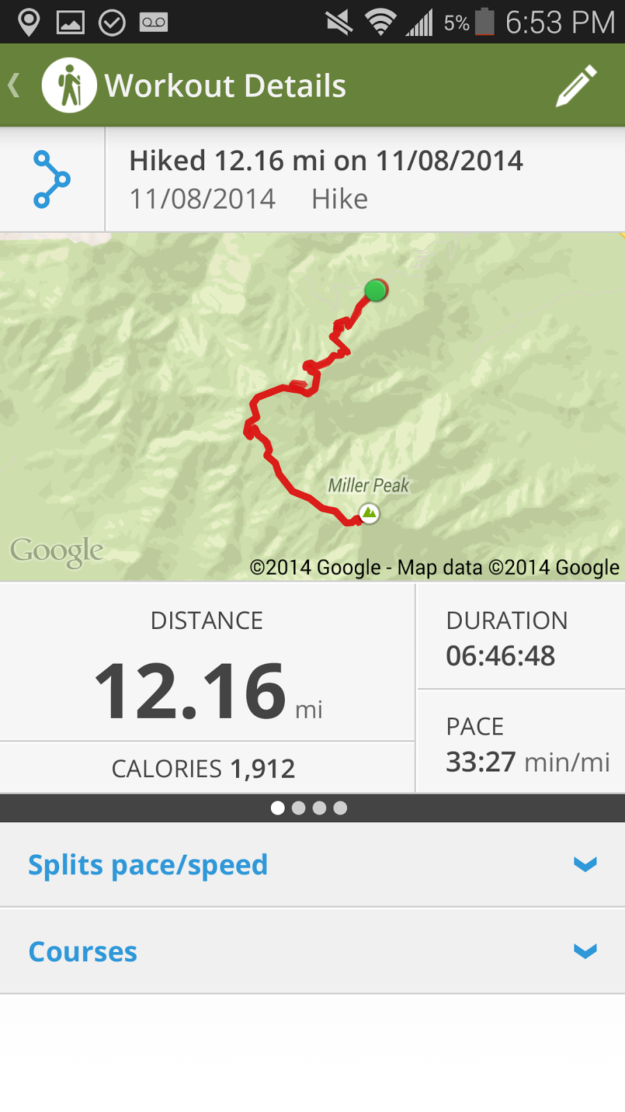
Workout details from the Map My Hike application. I only paused our time at the 2 peaks, so our total hiking time plus several short breaks ended up being less than 7 hours - not bad for 12 miles!


The elevation changes throughout the hike. This is why it was so easy! Once you make it to the intersection with the Carr Peak trail, it's all gradual changes, very easy and so worth it!

One last note - at Fort Huachuca in Sierra Vista, there is a tethered balloon surveillance system called the Aerostat. It was visible almost the entire hike, though in these pictures it turned out as a tiny speck. We joked about how it was watching us the entire time. It is visible in 4 of the pictures I posted - can you find them all? Click on the pictures to enlarge and look for them!